Unearthing the Roots of Kew Gardens’ History: Images of Kew
In this blog, Alyssa Myers reflects on her PhD placement Unearthing the Roots of Kew Gardens’ History, in collaboration with the Royal Botanic Gardens, Kew and Historic Royal Palaces. This project was funded by the North West Consortium Doctoral Training Partnership, part of the Arts and Humanities Research Council. The aim was to create a comprehensive inventory and finding aid of Kew’s pre-public era history (pre-1840).
-
Author
- heathercraddock
-
Published Date
- May 1, 2026
To create the finding aid, the first half of the placement was centred around images. From pulling together a range of maps, architectural drawings and prints, to sketches, watercolour drawings and paintings from archives across the country and globally. Combined, the images create a sense of what Kew Gardens would have looked like during the long eighteenth century, especially as the landscape has been significantly altered and several of the elaborate architectural features no longer exist today — or were never fully realised beyond the page. As the finding aid is arranged chronologically and by object type, this range of material has highlighted prominent areas of Kew’s history in a very visual way, leading to further categorisations and snapshots of particular moments in time.
Maps
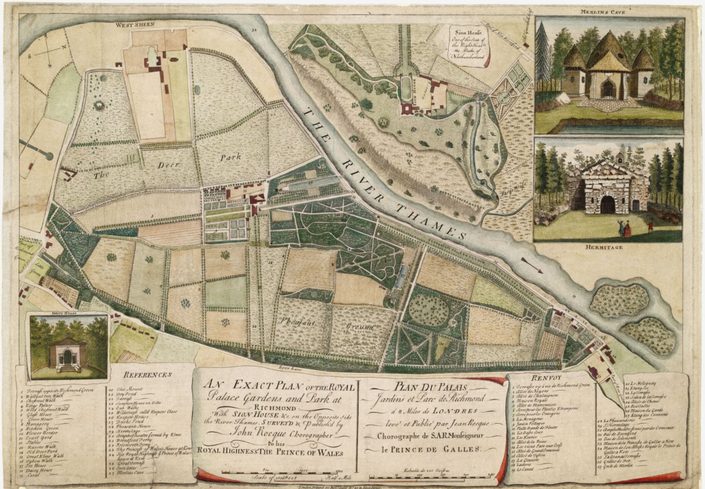
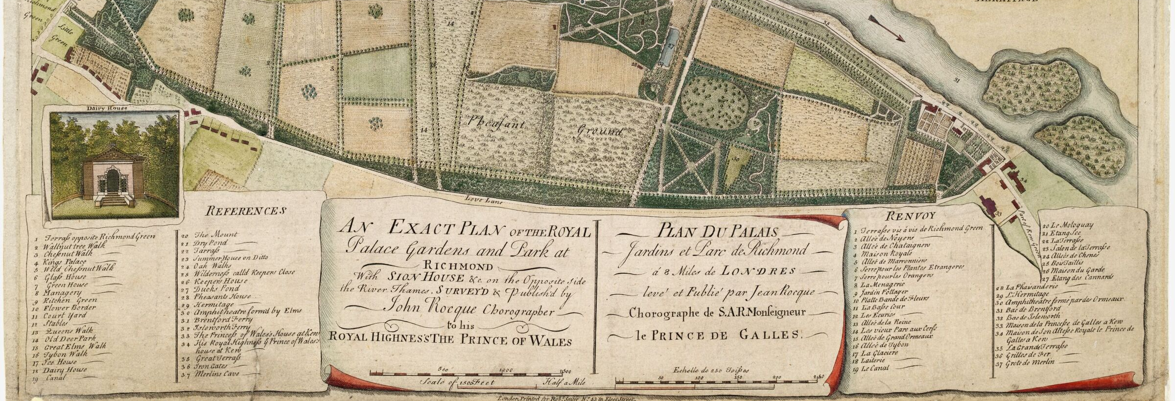
Some of the earliest maps to show the Royal Gardens at Richmond in detail are the series of maps by cartographer John Rocque. Rocque created four distinct additions: 1734, 1736, 1748 and 1754, each with their own additional variations and nuances. These highly artistic maps went beyond basic cartography to also depict the buildings and follies contained within the gardens, such as the Dutch House (now Kew Palace) and William Kent’s long demolished Hermitage and Merlin’s Cave, as well as accurate depictions of the landscape garden itself to show the layout of the garden design. Few other pre-1840 maps show Kew in such detail.
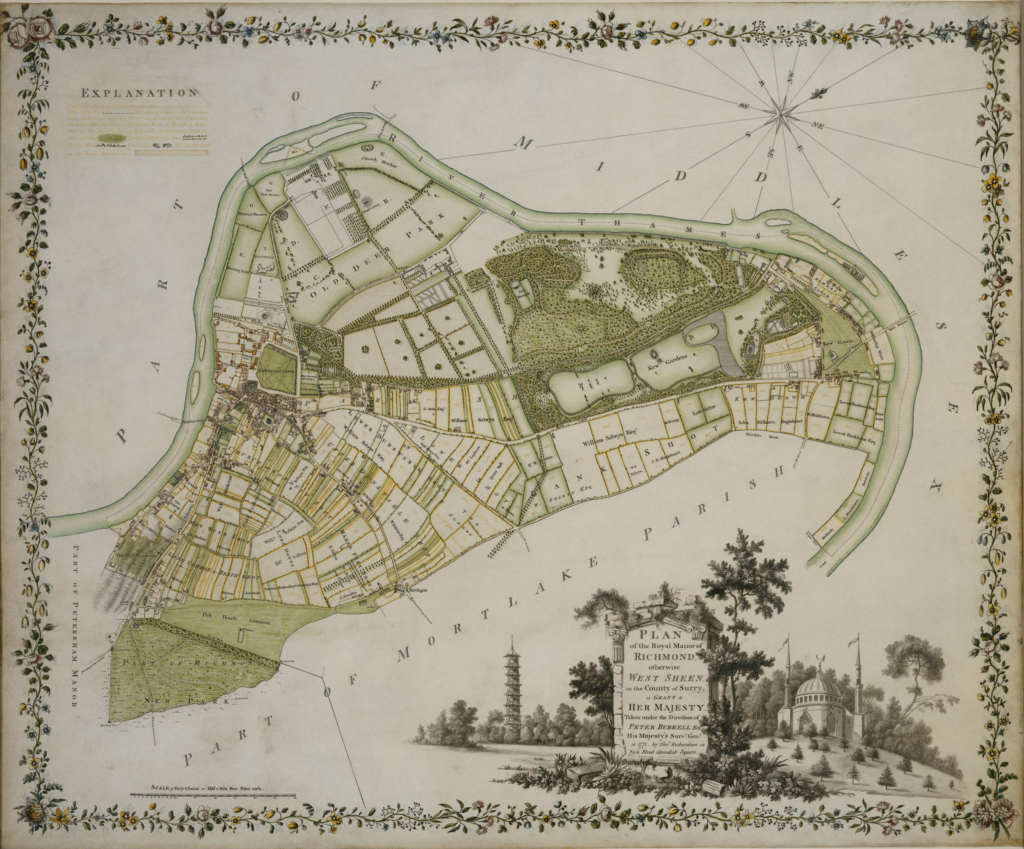
In the second half of the eighteenth century through to the first half of the nineteenth, maps tended to include Kew alongside Kew Green, Richmond and Richmond Park (New Park). There is a series of 1771 maps done by Peter Burrell and Thomas Richardson, in which Kew Gardens and the Old Richmond Park are the central focus of the surrounding areas of Richmond and West Sheen. Details such as the Royal Observatory and Menagerie were still included, but these maps also invoke a conversation between Kew and the houses and buildings which surrounded it and are an important reminder that Kew was part of a larger community.
William Chambers
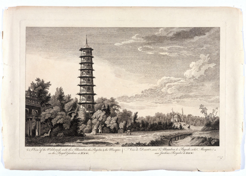
What started out as a section on architectural drawings was very quickly split into an additional section entirely devoted to architect William Chambers who designed numerous follies and buildings for Kew Gardens. His drawings take up around twenty-eight pages of the finding aid alone, not to mention all the subsequent prints and drawings based on his designs, such as the notorious Kew Pagoda. In 1757, Chambers was appointed the architectural tutor to the Prince of Wales, later George III and subsequently began working on the gardens for Princess Augusta at Kew House (the White House).
In 1763, he published ‘Plans, elevations, sections and perspective views of the gardens and buildings at Kew in Surrey, the seat of Her Royal Highness the Princess Dowager of Wales’ containing forty-three leaves of drawings for various architectural elements designed and built at Kew. Eight of these drawings depict Chambers’ designs set within the surrounding landscape at Kew, highlighting the diversity of the park and gardens. Very few of his built designs remain today. Chambers’ work spanned approximately ten or so years, only a fraction of the garden’s history, but his legacy has left a lasting impression.
Print Collection
While the maps and architectural drawings provide specific lenses in which to view Kew Gardens, the vast print collection provides a visual diary of the gardens’ history, showing us how the contemporary public saw Kew. Unlike individual drawings or maps, the range of available prints, in multiples, makes them accessible as an archival material and they have been found throughout archives and institutions across the globe. Scrolling through the thirty-two pages of prints in the finding aid, spanning roughly 100 years, certain timelines became clear through the patterns that emerged in content type.
The first half of the prints heavily feature the White House, a summer residence and occasional retreat taken by Frederick, Prince of Wales in 1730 and had it remodelled by William Kent shortly after. After Frederick’s death, the house was taken up by his widow, Augusta, the Dowager Princess of Wales. To add to the confusion, the White House sat directly opposite of Kew Palace (the Dutch House), which was used as a schoolhouse for Augusta’s eldest sons.
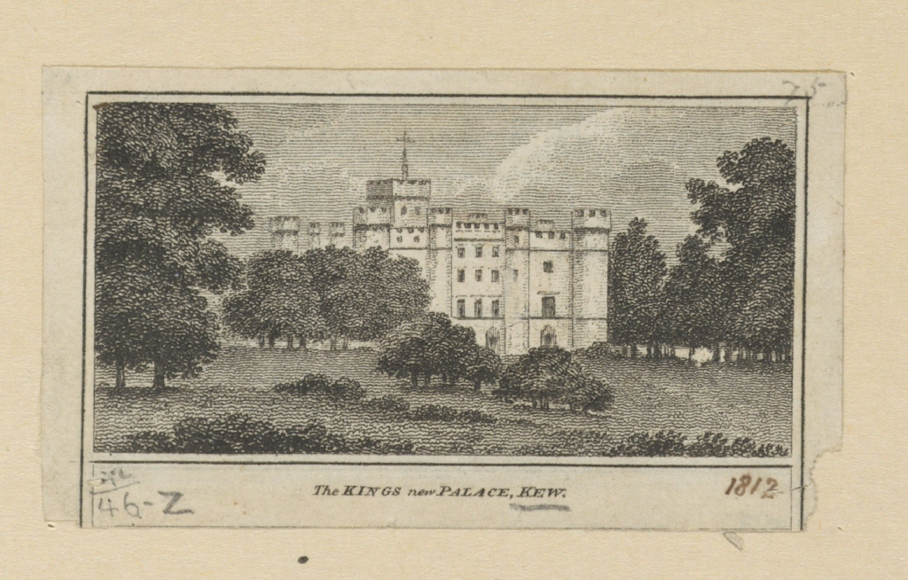
After Augusta’s death in 1772, George III demolished the old Richmond Lodge and took the White House as his summer residence, placing his two eldest sons in Kew Palace as their schoolhouse, which is why it was sometimes referred to as ‘the Prince of Wales’s House’. The shift in the archives around 1800 is quite a visual one, as George III decided to demolish the White House and hire James Wyatt to build him a magnificent, castellated palace, in-line with the fad for the Gothic. The Castellated Palace was never fully finished and was demolished by George IV in 1820, but the printed material of the time heavily reflected the intrigue of this castle.
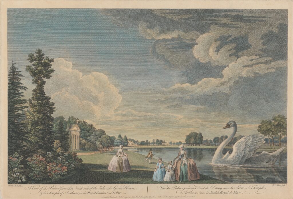
Because of the gardens’ royal ownership, the prints also tended to reflect current events relating to the gardens. For example, there was a regatta in 1755 that was held for the Prince of Wales’s birthday where a specially made ‘swan’ boat was launched in the gardens at Kew and is depicted in multiple images.
On the more scandalous side, the finding aid highlights four satirical prints from 1767–69 that are inconspicuously sandwiched between picturesque views of the gardens. These satires poke fun at the alleged affair between the Dowager Princess Augusta and the Earl of Bute, a Scottish aristocrat and botanist who advised Augusta regarding the layout of the gardens and who was also instrumental in choosing and acquiring plants for the botanical garden. These engravings are especially interesting because they highlight a very particular moment in time and depict the amorous couple within the bounds of Kew Gardens, with the pagoda in the background serving as the new icon of the gardens.
Generally, the assortment of prints, drawings and paintings tend to focus on architectural elements of Kew or picturesque views of the gardens and the wider Richmond locale (though occasionally, the gardens as a botanic entity are sometimes given pride of place). These works sit alongside contemporary maps and rare planting schemes. Alone, these visual materials help us to understand Kew Gardens at a time when it was very much not a public entity, but a Royal retreat. They bring to life long-lost palaces and architectural structures which in turn, show us how the gardens were used and valued as a built and designed space.
The second half of the placement brought in document-based archival material from archives throughout the country. These documents range from contracts, financial papers, manuscripts and memoranda to occasional correspondence. Where the visual material culture of the long eighteenth century tends to focus more on artistic aspects of Kew, the documentary evidence highlights the practical aspects of running and maintaining the gardens. The visual with the documentary balance each other out to provide an archival foundation for Kew Gardens’ history that will aid in research for years to come.
Alyssa Myers is a collaborative PhD student with Manchester Metropolitan University and English Heritage, researching ‘Suburban Villas in Eighteenth-Century London: Forms, Functions and Networks’.